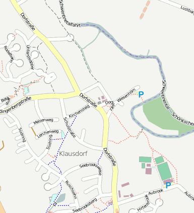
Schwentinental Klausdorf
Googlemaps
Fotos aus dem Umkreis von Schwentinental Klausdorf
Strassen in der Nähe vom Ortsteil Klausdorf
- Teichstraße (0.08km)
- Wiesenhörn (0.09km)
- Schwentinestraße (0.12km)
- Dorfplatz (0.13km)
- Dorfplatz (0.13km)
- Kirchensteig (0.14km)
- Schulstraße (0.24km)
- An der Bek (0.31km)
- Kiebitzweg (0.37km)
- Seebrookswiese (0.43km)
- An der Weide (0.46km)
- Bachstraße (0.5km)
- Reetsteg (0.53km)
| Arbeitsmarktdaten von Schwentinental, Stadt | |
|---|---|
| Sozialversicherungspflichtige | |
| nach Wohnort | 4324 |
| nach Arbeitsort | 4159 |
| Einpendler | 3531 |
| Auspendler | 3696 |
| Geringfügig Beschäftigte (400€ Basis) | |
| nach Wohnort | 1171 |
| nur GeB (Wohnort) | 817 |
| GeB als Nebenjob (Wohnort) | 354 |
| nach Arbeitsort | 1468 |
| nur GeB (Arbeitsort) | 1029 |
| GeB als Nebenjob (Arbeitsort) | 439 |
| Arbeitslose | ca. 5.16% |
| Gesamt | 311 |
| davon ALG I | 152 |
| davon HARTZ 4 (ALG II) | 159 |
| Frauenquote | 49.84% |
| Männerquote | 50.16% |
| Ausländerquote | 8.04% |
| © Arbeitsagentur u.a. | |
| Fakten zur Gemeinde Schwentinental, Stadt | |
|---|---|
| Gemeindeschlüssel | 01057091 |
| Regionalschlüssel | 010570091091 |
| Gemeindetyp | Stadt |
| Verwaltung | Raisdorf Theodor-Storm-Platz 1 24223 Raisdorf |
| Bevölkerungsdichte | 763 Ew. je km² |
| Fläche | 17,82 km² |
| Einwohner | 13588 |
| davon weiblich | 7073 |
| davon männlich | 6515 |
| GPS Latitude | 54.308994 |
| GPS Longitude | 10.213925 |
| Vorwahl | 0431 |
| Telefonnetz | Kiel |
| Land | Schleswig-Holstein |
| Landkreis | Plön |
| Gemeinde | Schwentinental, Stadt |
| Aktive Googlemaps-Karte von Schwentinental | |
| Aktive Openstreetmap-Karte von Schwentinental | |
| Steuersätze von Schwentinental, Stadt | |||
|---|---|---|---|
| Ort | Grundsteuer A | Grundsteuer B | Gewerbesteuerhebesatz |
| Schwentinental,Stadt | 270 | 280 | 320 |
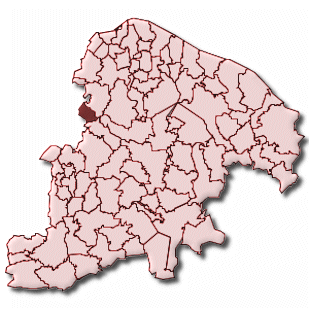
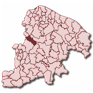
Gemeinde-Übersichtskarte(n)
Klausdorf
Raisdorf
Kartenausschnitt von Yahoo